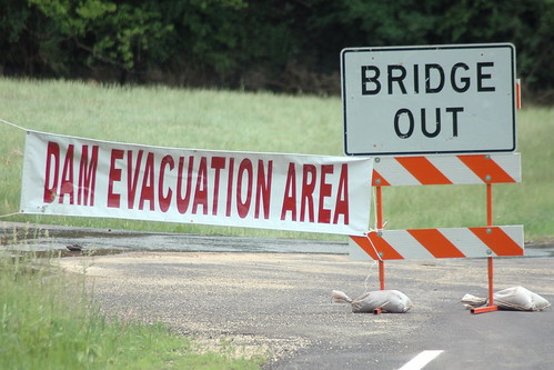
while the heavy rains wreaked havoc across vernon county the brunt of the flooding happened along the kickapoo river from ontario through la farge and on to viola ( la farge is home to organic valley ).
the kickapoo is named after the Algonquin word meaning “one who goes there, then here" as it meanders nearly 130 miles from its source in wilton to wauzeka, where it joins the wisconsin river – a distance of only 60 miles "as the crow flies"!
so it’s twisty and turny and has a low capacity for water to boot, which means locals are used to flooding, but they haven’t seen anything like this since the big flood of 1978, with the river cresting to 21 feet or about 8 feet above flood stage.
the big concern was whether the county’s 22 flood control dams would hold after being weakened by the "100 year flood" that happened just 10 months ago.
while there were early reports of some dams failing which led to evacuations as of monday there was cautious optimism that they would hold, "”All of our dams are holding. They have suffered damage. There is still the potential for some of them to fail.”"
we’re all safe and sound. other than a few inches of water in the basement, my biggest problem is trying to figure out how to navigate the numerous road closures and evacuation areas to get to work.
if you’re feeling adventurous you could peruse the road closures map and try and figure out how to get me from viroqua to la farge without adding 30 miles to my daily commute 🙂

What to say except please be careful and stay safe!
I don’t suppose they’ll let you telecommute? :o)
esta: “What to say except please be careful and stay safe!”
thanks! we’re safe and sound and much dryer than a lot of our neighbors.
RocketGrl: “I don’t suppose they’ll let you telecommute? :o)”
in theory i can, but in practice it’s painful to many of the data intensive things i have to do over vpn/remote desktop.